Marker Collection Display Icon
In this guide you will learn how to show locations,
or POIs (points of interest) on a map using an icon image,
and optionally draw a polyline connecting the POIs.
Setup
First, get an API key token, see the Getting Started guide.
Download the Maps & Navigation SDK for Android archive fileDownload the MarkerCollectionDisplayIcon project archive file or clone the project with Git
See the Configure Android Example guide.
Run the example
In Android Studio, from the File menu, select Sync Project with Gradle Files
|
|||
An android device should be connected via USB cable.
Press SHIFT+F10 to compile, install and run the example on the
android device.
How it works
You can open the MainActivity.kt file to see how rendering icons on a map to indicate POIs works.
 1private fun getBitmap(drawableRes: Int): Bitmap? {
 2     val drawable = if (Build.VERSION.SDK_INT >= Build.VERSION_CODES.LOLLIPOP) {
 3         ResourcesCompat.getDrawable(resources, drawableRes, theme)
 4     } else {
 5         ContextCompat.getDrawable(this, drawableRes)
 6     }
 7     drawable ?: return null
 8     val canvas = Canvas()
 9     val bitmap = Bitmap.createBitmap(
10         drawable.intrinsicWidth,
11         drawable.intrinsicHeight,
12         Bitmap.Config.ARGB_8888
13     )
14     canvas.setBitmap(bitmap)
15     drawable.setBounds(0, 0, drawable.intrinsicWidth, drawable.intrinsicHeight)
16     drawable.draw(canvas)
17     return bitmap
18}
The icon bitmap image is obtained from the resources included
with the project, located in res/drawable, and specified using an int id,
as this project includes more than one bitmap image.
1private fun toPngByteArray(bmp: Bitmap): ByteArray {
2     val stream = ByteArrayOutputStream()
3     bmp.compress(Bitmap.CompressFormat.PNG, 100, stream)
4     val byteArray: ByteArray = stream.toByteArray()
5     bmp.recycle()
6     return byteArray
7}
This function is used to convert the image to a PNG bytearray,
as PNG images are lossless, like bitmaps, but are also compressed.
1override fun onCreate(savedInstanceState: Bundle?) {
2 super.onCreate(savedInstanceState)
3 binding = ActivityMainBinding.inflate(layoutInflater)
4 setContentView(binding.root)
5 val mapSurface = binding.gemSurface
6 mapSurface.onDefaultMapViewCreated = { mapView ->
7 val predefinedPlaces = arrayListOf(
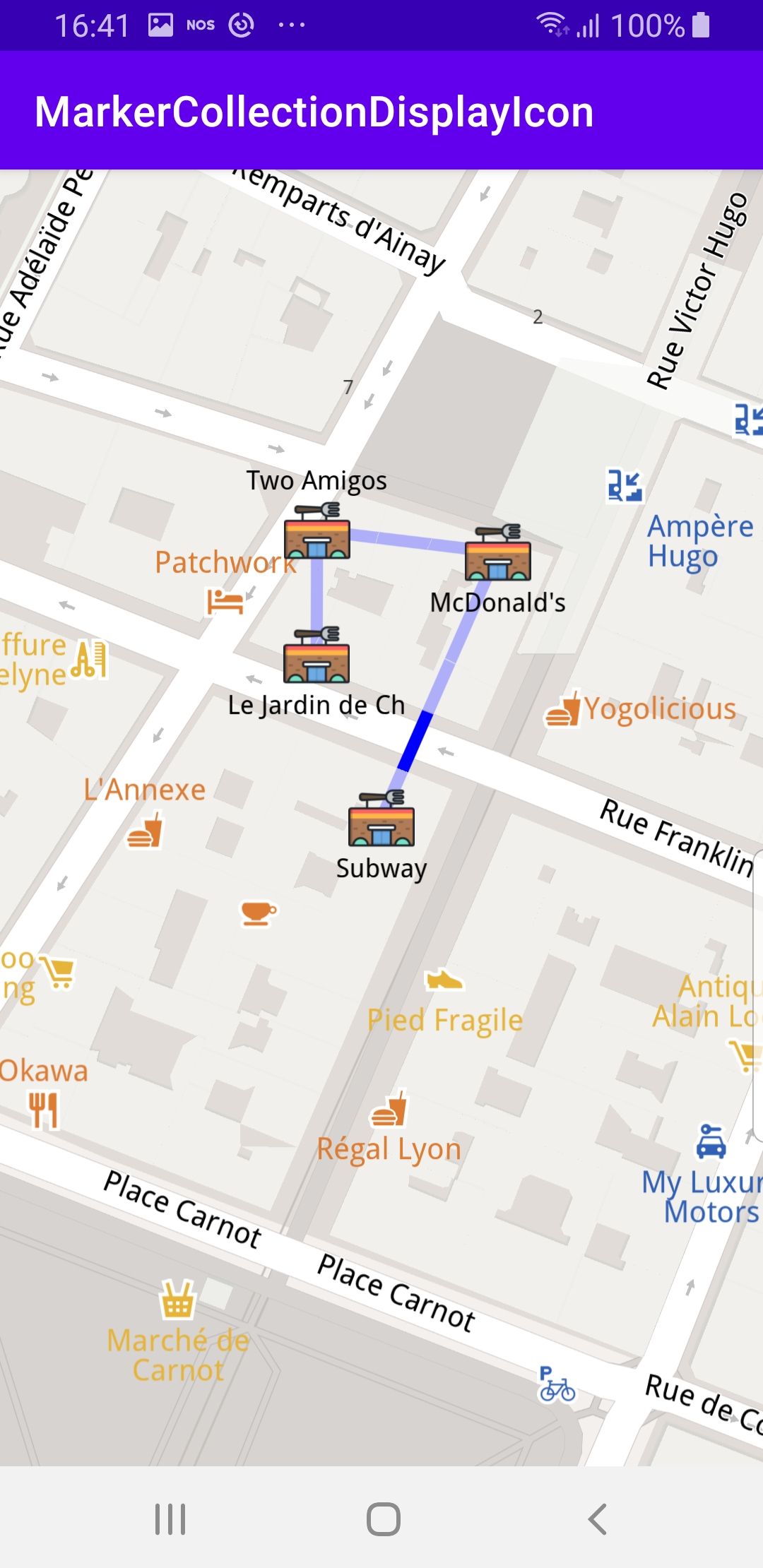
8 Pair("Subway", Coordinates(45.75242654325917, 4.828547972110576)),
9 Pair("McDonald's", Coordinates(45.75291679094701, 4.828855627148713)),
10 Pair("Two Amigos", Coordinates(45.75295718457783, 4.828377481057234)),
11 Pair("Le Jardin de Chine", Coordinates(45.75272771410631, 4.828376649181688)),
12 )
13 /* Image and text */
14 val imageTextsCollection = MarkerCollection(EMarkerType.Point, "Restaurants Nearby")
15 for (place in predefinedPlaces) {
16 Marker().apply {
17 setCoordinates(arrayListOf(place.second))
18 name = place.first
19 imageTextsCollection.add(this)
20 }
21 }
22 val image = getBitmap(R.drawable.ic_restaurant_foreground)?.let {
23 Image.produceWithDataBuffer(DataBuffer(toPngByteArray(it)), EImageFileFormat.Png)
24 }
25 val imageTextsSettings = MarkerCollectionRenderSettings(image)
26 imageTextsSettings.labelTextSize = 2.0 //mm
27 imageTextsSettings.labelingMode = EMarkerLabelingMode.Item
28 mapView.preferences?.markers?.add(imageTextsCollection, imageTextsSettings)
29 /* Polyline */
30 val polylineCollection = MarkerCollection(EMarkerType.Polyline, "Polyline")
31 Marker().apply {
32 for (place in predefinedPlaces)
33 add(place.second)
34 polylineCollection.add(this)
35 }
36 val polylineSettings = MarkerCollectionRenderSettings(polylineInnerColor = Rgba.blue())
37 polylineSettings.polylineInnerSize = 1.5 //mm
38 mapView.preferences?.markers?.add(polylineCollection, polylineSettings)
39 /* Center map on result */
40 mapView.centerOnCoordinates(predefinedPlaces[0].second, 80)
41 }
42 if (!Util.isInternetConnected(this)) {
43 Toast.makeText(this, "You must be connected to internet!", Toast.LENGTH_LONG).show()
44 }
45}
The
MainActivity overrides the onCreate() function which checks that
internet access is available, and then, when the map is instantiated, defines
an array containing 4 POI (points of interest - restaurants in this case)
coordinate pairs - name, latitude, longitude:mapSurface.onDefaultMapViewCreated = { mapView ->val predefinedPlaces = arrayListOf(Next, the icon image is added to the name and coordinates of each POI:
val imageTextsCollection = MarkerCollection(EMarkerType.Point, "Restaurants Nearby")for (place in predefinedPlaces) {Next, a polyline is added, connecting the restaurants with a path going
linearly through each, once:
val polylineCollection = MarkerCollection(EMarkerType.Polyline, "Polyline")Marker().apply {for (place in predefinedPlaces)The color and width of the polyline are set:
val polylineSettings = MarkerCollectionRenderSettings(polylineInnerColor = Rgba.blue())polylineSettings.polylineInnerSize = 1.5 //mmThe map is then centered on the first POI in the list (index 0):
mapView.centerOnCoordinates(predefinedPlaces[0].second, 80)As the other POIs are nearby, they are all in view.